Information Material for the i-GeoVET Platform

Complete archive of announcements and technical presentations of the epizootic platform, i-GeoVET.

PRESENTATION • November 2026

The i-GeoVET Presentation from the 2026 ArcGIS User Conference for Greece & Cyprus Is Now Available

On October 21, 2026, at the ArcGIS User Conference for Greece & Cyprus, we presented i-GeoVET, ELGO-DIMITRA's geospatial epizootic management platform, and its operational use against foot-and-mouth disease on Lesvos. The slides are now available for anyone who wants to view them.
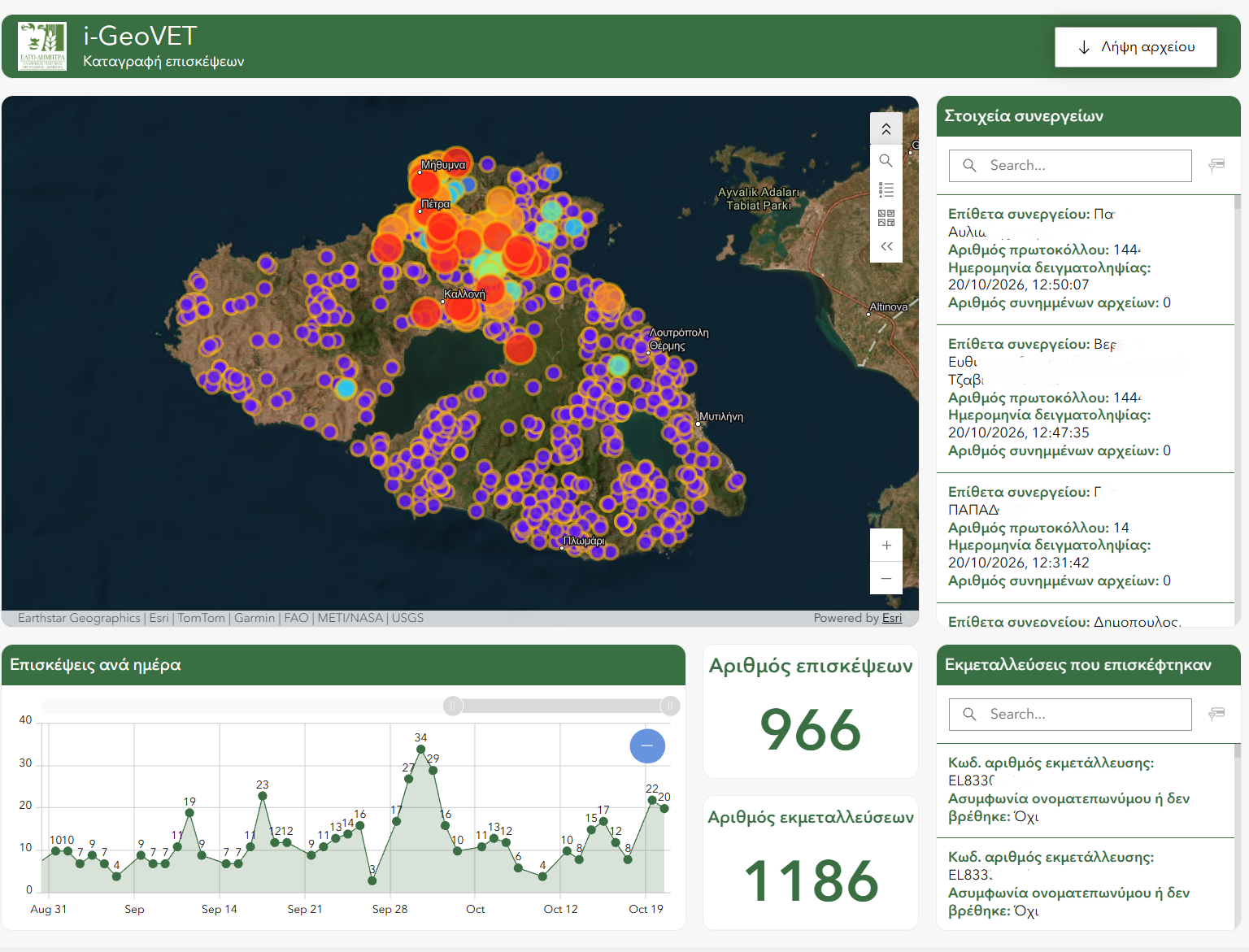
Dashboard recording crew visits in Lesvos, October 2026
Crew visits in mid-October 2026. Red marks the visits of the specific day and orange those of the previous day.

Key points:

  • One platform, three epizootics: peste des petits ruminants (2024), sheep pox (2025), foot-and-mouth disease (2026).
  • Sheep pox 2025: spatiotemporal tracking of outbreaks, from 61 by 31/05/2025 to 820 by 10/10/2025.
  • Lesvos 2026: on-site recording of visits and sampling from mobile devices, monitored on an operations dashboard.
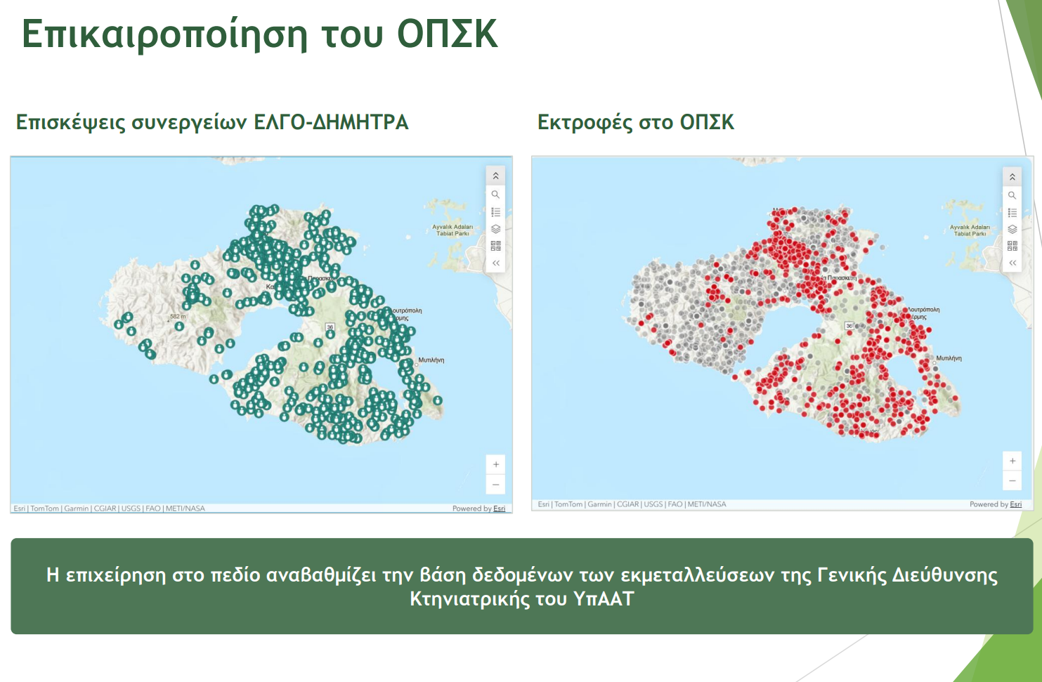
  • Updating the Integrated Veterinary Information System: field visits upgrade the farm database of the General Directorate of Veterinary Services of the Ministry of Rural Development and Food.
  • Data quality: 15 checks in 7 categories.
PRESENTATION • October 2026

Presenting i-GeoVET at the 2026 ArcGIS User Conference for Greece & Cyprus

Effective epidemic management requires swift virus detection, immediate control measures, and precise mapping of farms, cases, and protection or surveillance zones.

To address this challenge, the GIS Lab of the Soil & Water Resources Institute (SWRI), with the Veterinary Research Institute (VRI) of ELGO-DIMITRA, developed i-GeoVET. Built on the ArcGIS platform, i-GeoVET serves as a specialized geospatial tool for animal disease control.

i-GeoVET Presentation at 2026 ArcGIS User Conference
i-GeoVET platform presentation at the 2026 ArcGIS User Conference.

The system was successfully deployed in field operations during:

  • The sheep pox outbreak in 2025.
  • The foot-and-mouth disease outbreak in Lesvos in 2026.

We will present our work and operational outcomes at the 2026 ArcGIS User Conference for Greece & Cyprus.

Presentation Details:

  • Date: Wednesday, October 21, 2026
  • Time: 14:30
  • Hall: 1 E
  • Location: Crowne Plaza Athens (as part of the conference on October 21–22)
INTERACTIVE MAP • August 2026

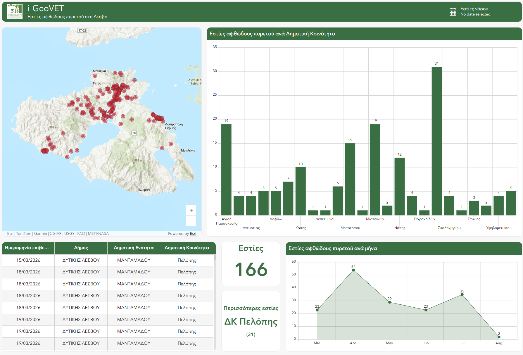
The Evolution of Foot and Mouth Disease in Lesvos (March to August 2026)

Foot and Mouth Disease Dashboard in Lesvos
Foot and Mouth Disease Dashboard in Lesvos.

Monitor the course of the disease through i-GeoVET. The application captures the evolution of foot and mouth disease in Lesvos. The data covers the period from March 15 2026 (WAHIS data source).

You can examine the cases on the island in detail. The interactive visualization helps you understand the geographic distribution of the disease.

OPERATIONAL PROGRESS • July 10, 2026

Intensive Foot and Mouth Disease Surveillance: Over 50% of Lesvos Covered by ELGO-DIMITRA

The field actions of ELGO-DIMITRA on the island of Lesvos continue unabated. According to the latest data on July 10, 2026, field crews have already covered more than 50% of the island's area through systematic visits to local herds.

Visit coverage map
Mapping of areas covered by veterinary visits.

Action Report:

The presence of field teams translates into a highly important prevention and control operation:

  • 300+ visits: In total, over 300 targeted visits have taken place at 403 livestock farms on the island.
  • 58,211 animals inspected: The process has covered a large number of livestock. This ensures early diagnosis and control of the epizootic.
DIGITAL SUPERVISION • June 2026

i-GeoVET: Comprehensive Digital Recording of Foot and Mouth Disease in the field by ELGO-DIMITRA

In June 2026, the i-GeoVET platform took a central role in the operational supervision of foot and mouth disease. It provides a strong supervisory system to gather and analyze all data from ELGO-DIMITRA's crew operations.

i-GeoVET Platform
Overview image of the i-GeoVET platform
Mobile Application
The mobile app in the field

Innovation in Data Collection:

The key to effective crisis management is using a specialized mobile application (mobile app) by field crews. The app turns every field visit into actionable information for decision making. The process ensures:

  • Reliable Recording: Immediate digital information entry, eliminating the margin for error.
  • Visual Material & Data: The ability to capture and send photos of animals and facilities (barns) offers a complete picture of the situation.
  • Immediacy: The overall epidemiological picture is sent in real time to the central platform, accelerating decisions to tackle Foot and Mouth Disease.
FIELD TECHNOLOGY • May 2026

i-GeoVET: Digital Protection Net in South Lesvos

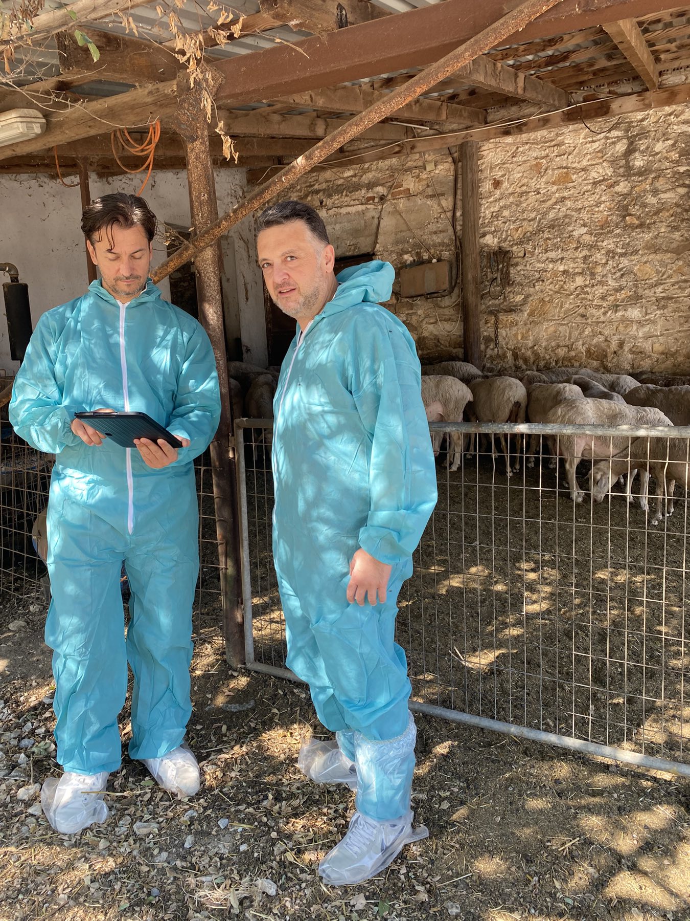
Veterinarian in the field with a tablet
Veterinarians record epizootic data using i-GeoVET on a tablet.

In a critical fight to limit the spread of Foot and Mouth Disease, Geographic Information Systems (GIS) technology proves to be the most valuable ally for veterinary authorities in Lesvos.

Activating the i-GeoVET system allows immediate and reliable response in the field. This tool changes the game in epizootic management:

  • ELGO-DIMITRA Coordination: Provides central support to scientists, veterinary, and scientific bodies, ensuring precision in decision making.
  • Real Time Recording: Field crews enter data immediately, enabling digital disease mapping.
  • Speed & Reliability: The ability to instantly visualize outbreaks allows authorities to limit the spread at a speed traditional methods did not permit.